Discover Indian Rivers: Maps, Features, Facts, And Images
In India, rivers are super important. They’re not just water – they’re like big, flowing veins that keep everything alive and thriving. They start from the snowy mountains & travel through different places. People use them for lots of things like drinking water, watering crops, & making electricity. But they’re more than that – they’re like storytellers of our history and culture. They’re places where people go to pray & find peace. In this blog, we’ll explore why Indian rivers are so special & what they mean to those who live alongside them. Let’s explore the amazing rivers of India together!
Like The River, Keep On Flowing!!
7 Longest Indian Rivers: Name, Pictures and Maps
Ganga River
The Ganga River flows through northern India, covering states like Uttarakhand, Uttar Pradesh, Bihar, and West Bengal. It’s about 2,525 kilometers long, starting from the Himalayas and eventually merging into the Bay of Bengal. Hindus consider it a holy river.
Facts About The Ganga River
- It provides water to over 400 million people, supporting agriculture, industry, and daily activities.
- The Ganga River is considered sacred by Hindus, who believe bathing in its waters cleanses sins.
- The Ganga’s annual floodplain supports fertile agricultural lands, crucial for food production in the region.
- The river sustains diverse wildlife, including the Ganges river dolphin, an endangered species.
- Varanasi, one of the oldest continuously inhabited cities, thrives along the Ganges’ banks, attracting pilgrims and tourists.
- Despite its religious significance, pollution threatens the Ganga, prompting cleanup efforts and conservation projects.
Images/Map Of India Ganges River
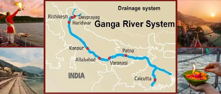
If you’re eager to explore the Ganga River from Kolkata, begin by booking a flight from the USA to Kolkata. hop on a bus or a taxi to reach the nearest city or town close to your Ganga River.
Brahmaputra River
The Brahmaputra River originates in Tibet and flows through India and Bangladesh, covering areas like Assam and Bangladesh’s Brahmaputra Valley. It’s around 2,900 kilometers long and is vital for agriculture and transportation in the region. The river’s diverse ecosystem supports various species of plants and animals.
Facts About The Brahmaputra River
- The Brahmaputra’s fast flow and shifting routes make it hard to travel.
- Brahmaputra’s floods are both destructive and vital, replenishing soil fertility in the region.
- It’s a lifeline for millions, providing water for agriculture, transportation, and livelihoods.
- The river’s name means “Son of Brahma” in Sanskrit, reflecting its spiritual significance in Hinduism.
- The Brahmaputra River is also called the Red River of India.
- Every year the Brahmaputra River Truns into red color in June for 3 days and a big Abubachi Mela is held to celebrate.
Brahmaputra River Assam India Map/Images
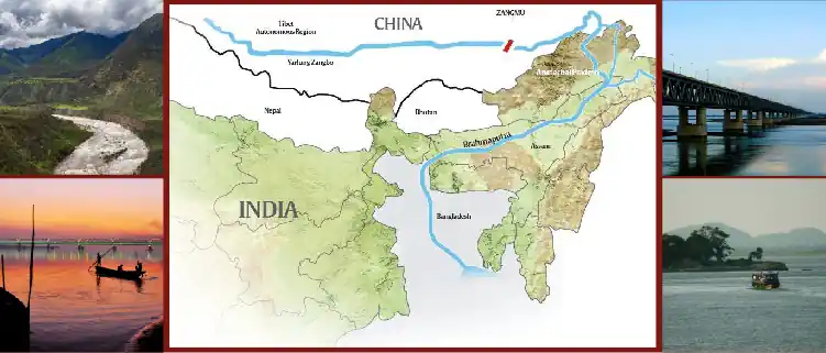
If you want to explore the Brahmaputra River from Delhi, begin by booking a flight from the USA to Guwahati. Then you can reach the nearest city by booking a Bus or Taxi.
Godavari River
It’s the second-longest river in India, flowing for about 1,465 kilometers long. The Godavari River, originating in the Western Ghats of Maharashtra, flows through states like Telangana, Andhra Pradesh, and Odisha. The river basin supports agriculture and is home to diverse flora and fauna.
Facts About The Godavari River
- The name “Godavari” is derived from the ancient Sanskrit words “go,” meaning cow, and “davari,” meaning giver of wealth or water. Therefore, the river Godavari is often referred to as the “Giver of Wealth” or the “River of Plenty.”
- Godavari is known for its scenic beauty, with greenery and beautiful landscapes along its banks, making it a popular tourist destination.
- The Godavari River is often called the “Ganga of the South” due to its importance in southern India’s culture and economy.
- Several dams and reservoirs have been built along the Godavari for irrigation, hydroelectric power generation, and drinking water supply.
- The Godavari Pushkaralu, a religious festival held every 12 years, attracts millions of devotees to bathe in the river.
Godavari River India Map/Images
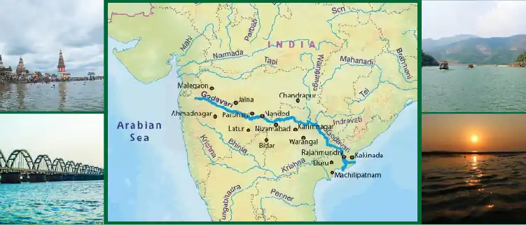
If you want to explore Godavari River, then book a direct flight from the USA to Hyderabad. After reaching you can book a Bus or a taxi to reach the nearest city.
Indus River
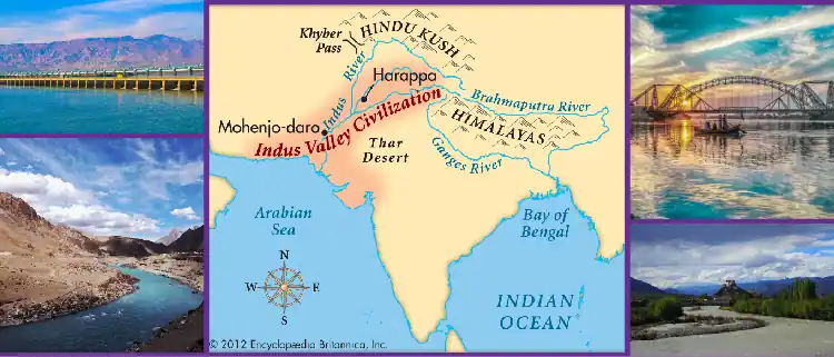
The Indus River flows through Pakistan, India, and China, covering about 3,180 kilometers. Originating in the Tibetan Plateau, it passes through the Ladakh region of India and the Gilgit-Baltistan region of Pakistan. The river supports agriculture and is vital for Pakistan’s economy, historically known for the ancient Indus Valley Civilization.
Facts About the Indus River
- It is also known as the Sindhu River.
- The river basin supports agriculture, providing water for crops and livestock.
- The Indus River is known by different names in various languages and regions. Sindhu River (Sanskrit), Sengge Chu (Tibetan), Sindhu Nadi (Hindi), Sindhū Nadī (Sanskrit.
- It has historically been a significant trade route, connecting civilizations and facilitating cultural exchange.
- It is known for and fast-flowing water, making it suitable for rafting and other adventure sports.
- The river’s lower course forms the fertile Indus Plain, known as Punjab in Pakistan, which is agriculturally rich and densely populated.
- The name “Indus” is derived from the ancient Sanskrit word “Sindhu,” meaning river. It’s believed that the term “Sindhu” was mispronounced as “Indus” by the ancient Persians, and the name stuck.
- The Indus River’s significance extends beyond Pakistan – it serves as a transboundary river, influencing geopolitics and water-sharing agreements among countries in the region.
- The river’s historical importance is evidenced by numerous archaeological sites along its banks, including Mohenjo-Daro and Harappa, showcasing the ancient civilization’s advanced urban planning and infrastructure.
- The Indus River is prone to flooding during the monsoon season, impacting communities and infrastructure in its floodplains.
Indus River India Map/Images
Yamuna River
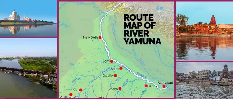
The Yamuna River flows through northern India, covering states like Uttarakhand, Himachal Pradesh, Haryana, and Uttar Pradesh. It’s about 1,376 kilometers long, originating from the Yamunotri Glacier in the Himalayas. The river passes through major cities like Delhi and Agra before merging with the Ganges in Allahabad.
Facts About The Yamuna River
- The Yamuna River is sacred in Hinduism and is admired alongside the Ganges.
- It originates from the Yamunotri Glacier in the Himalayas and flows through northern India.
- The river passes through major cities like Delhi, Agra, & Mathura, playing a vital role in their history and culture.
- Unfortunately, the Yamuna is highly polluted, primarily due to untreated sewage and industrial waste.
- Efforts are ongoing to clean up the river and restore its health, but challenges remain due to rapid urbanization & industrialization along its banks.
- Despite its pollution problems, the Yamuna remains significant for millions of people, both spiritually and economically.
- Mathura, situated on the banks of the Yamuna River, is believed to be the birthplace of Lord Krishna.
- The river holds immense religious significance for Krishna devotees, who perform rituals and ceremonies along its banks.
- According to Hindu mythology, Krishna spent his childhood in Mathura and performed various miraculous deeds along the Yamuna’s shores.
- The town of Vrindavan, closely associated with Krishna’s childhood located near Mathura on the banks of the Yamuna.
- Every year, thousands of pilgrims visit Mathura to participate in festivals & celebrations honoring Lord Krishna and to take holy dips in the Yamuna River, seeking spiritual purification.
Yamuna River India Map/Images
If you’re eager to explore the Yamuna River from Delhi, begin by booking a flight from the USA to Delhi. Once in Delhi, you can book a bus or taxi to reach the nearest city or town close to your Yamuna River.
Narmada River
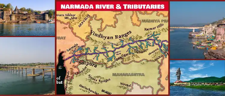
The Narmada River flows through central India, covering states like Madhya Pradesh, Maharashtra, & Gujarat. It’s about 1,312 kilometers long, originating from the Amarkantak Plateau in Madhya Pradesh. The river passes through scenic landscapes & provides water for irrigation, & hydroelectric power, & sustains diverse ecosystems along its banks.
Facts About The Narmada River
- The Narmada River is India’s 5th longest river and the longest west-flowing river.
- Significant religious importance in Hinduism – connected to Lord Shiva and one of the seven holy rivers.
- A popular destination for pilgrims participating in the Narmada Parikrama pilgrimage circuit.
- Provides water resources essential for agriculture and human consumption in MP and Gujarat.
- Helps maintain ecological balance in its watershed areas and supports diverse flora and fauna species.
- Contributes significantly to the tourism industry of MP and Gujarat due to its scenic beauty along banks and numerous religious sites.
- Facing pollution challenges conservation efforts are underway to preserve its cultural and ecological significance.
- This river flows in a big crack in the ground and splits North India from South India.
- There are many big waterfalls along this river, like the Dhuandhar Falls near Jabalpur.
Narmada River In Indian Map/Images
Krishna River
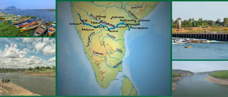
The Krishna River is one of the longest rivers in India, originating from the Western Ghats in Maharashtra. It flows through the states of Maharashtra, Karnataka, Telangana, and Andhra Pradesh before draining into the Bay of Bengal. Spanning about 1,400 kilometers, it sustains agriculture, and hydroelectric power, and supports diverse ecosystems along its course.
Facts About The Krishna River
- Important urban centers like Sangli, Vijayawada, and Machilipatnam are situated on its course.
- Faces severe pollution due to untreated sewage and industrial waste.
- The river has a unique delta ecosystem at its mouth, known as the Krishna Delta, which supports diverse flora and fauna and serves as an important breeding ground for fish and aquatic species.
- It is the site of several major dams and reservoirs, such as the Srisailam Dam and Nagarjuna Sagar Dam, which regulate water flow and provide water for irrigation and electricity.
- Krishna River has a rich cultural significance, particularly in Hindu mythology, where it is associated with Lord Krishna’s childhood and various legendary stories.
- Devotees perform rituals and ceremonies along the river’s banks, seeking blessings and spiritual purification.
Krishna River In India Map/Images
If you want to explore the Krishna River, start by booking a flight from the USA to Bangalore. You can catch a Bus or a train to reach the nearest city or town close to your destination in Banglore.
Indian River System
- Himalayan Rivers –
- Originating from the Himalayas, these rivers are fed by snowmelt and glaciers.
- Major rivers include the Ganga, Yamuna, Brahmaputra, Indus, and their tributaries.
- These rivers flow through the northern and northeastern regions of India.
- Peninsular Rivers –
- Originating from the peninsular plateau and Western Ghats, these rivers flow towards the east and west coasts of India.
- Major rivers include the Godavari, Krishna, Kaveri, Narmada, & Tapi.
- They are rain-fed & experience seasonal variations in flow.
- Major River Basins –
- Ganga-Brahmaputra Basin – Covers the northern & northeastern parts of India, draining into the Bay of Bengal.
- Godavari Basin – Drains into the Bay of Bengal & is the second-longest river in India.
- Krishna Basin – Flows through Maharashtra, Karnataka, Telangana, & Andhra Pradesh, eventually draining into the Bay of Bengal.
- Kaveri Basin – Flows through Karnataka & Tamil Nadu, reaching the Bay of Bengal.
Geographical Features Of Indian Rivers
- Origin – Indian rivers start from different places. Some come from the Himalayan mountains, where there’s lots of snow. Others begin in hills or plateaus.
- Length and Size – They vary in size. Some rivers are long, like the Ganges & Brahmaputra, while others are smaller.
- Course – Rivers flow through different states and regions of India. They twist and turn, creating curves & bends along the way.
- Tributaries – Many rivers have smaller rivers joining them along their journey. These smaller rivers are called tributaries.
- Deltas – Some rivers, like the Ganges & Brahmaputra, end in a wide area of land called a delta. Deltas are formed when rivers deposit soil & sediment in their mouths.
- Erosion and Deposition – Rivers shape the land around them. Rivers break down rocks and dirt, making valleys and canyons. They also leave behind mud and sand, which can make the ground higher in some places.
- Flora and Fauna – Indian rivers support diverse plant & animal life. You can find trees, bushes, fish, birds, & other creatures along their banks and in the water.
- Waterfalls and Rapids – Some rivers have waterfalls & rapids along their course. These create exciting & beautiful natural sights.
- Importance for People – People rely on rivers for water, transportation, agriculture, and more. They have been essential for settlements & civilizations throughout history.
- Challenges – Indian rivers face challenges like pollution, overuse of water, & habitat destruction. Protecting them is important for the environment & future generations.
Historical Significance Of India Rivers
- Early Settlements – Rivers provided water, food, & transportation for ancient civilizations. Many early settlements grew along the banks of rivers like the Indus and Ganges.
- Trade Routes – Rivers served as important trade routes, allowing goods & ideas to flow between different regions. Traders used boats to transport goods along rivers, connecting distant communities.
- Cultural Development – Rivers influenced the development of Indian culture and society. They inspired art, literature, & religious beliefs. Many sacred sites & temples are located along riverbanks.
- Hydraulic Engineering – Ancient civilizations developed sophisticated irrigation systems to harness the water of rivers for agriculture. They built canals, dams, & reservoirs to control the flow of water & support farming.
- Battlefields – Rivers often played a strategic role in historical battles & conflicts. They served as natural barriers or routes of invasion, shaping the course of warfare in ancient India.
- Religious Significance – Indian rivers hold deep religious significance for Hindus and other faiths. They are considered holy, & rituals like bathing and offering prayers are performed in their waters.
- Symbolism – Rivers are often used as symbols in Indian mythology and literature. They represent life, purity, & the cycle of creation and destruction.
- Monuments and Landmarks – Many historical monuments & landmarks are located near rivers. Forts, palaces, & ancient cities were often built along riverbanks for strategic and practical reasons.
- Economic Prosperity – Rivers contributed to the economic prosperity of ancient Indian civilizations. They supported agriculture, fishing, trade, & industries like textiles and pottery.
- Cultural Heritage – Indian rivers are an integral part of the country’s cultural heritage. They have countless songs, poems, & stories, reflecting their significance in Indian society.
Ecological Importance Of Indian Rivers
- Habitat for Wildlife – Rivers provide homes for many animals, like fish, birds, and insects.
- Biodiversity – Indian rivers have lots of different plants & animals, making them rich in biodiversity.
- Migration Paths – Some animals, like fish and birds, use rivers to travel from one place to another during certain times of the year.
- Water for Life – Rivers give water for drinking, farming, and keeping plants alive. Many people & animals depend on rivers for survival.
- Rain and Groundwater – Rivers help make rain and keep underground water levels healthy. This is important for growing crops & keeping the land fertile.
- Preventing Floods – Rivers can absorb extra water during heavy rain, which helps stop flooding in nearby areas.
- Fertile Soil – Rivers bring soil and nutrients to the land, making it good for growing crops. Areas near rivers are often very fertile.
- Cleaning Water – Rivers naturally clean the water as it flows, making it safe for animals & people to use.
- Cooling the Air – Rivers can make the air around them cooler, especially in hot places. River helps plants & animals stay comfortable.
Economic Contributions Of Indian Rivers
- Water for Agriculture – Rivers provide water for farming, helping to grow crops like rice, wheat, and sugarcane that feed millions of people.
- Hydropower Generation – Indian rivers are used to generate electricity through hydropower plants, which provide energy for homes, businesses, and industries.
- Transportation – Rivers serve as natural highways, allowing boats and ships to transport goods like food, clothes, & raw materials to different places.
- Fishing Industry – Rivers support a growing fishing industry, providing livelihoods for fishermen and supplying fish for food & trade.
- Tourism and Recreation – Rivers attract tourists who enjoy activities like boating, rafting, and wildlife watching, contributing to the economy through tourism revenue.
- Water Supply – Many industries rely on rivers for water, including manufacturing, mining, and construction, which support economic growth and employment.
- Irrigation – Rivers are used to irrigate farmland, increasing agricultural productivity and helping farmers grow more crops throughout the year.
- Industrial Use – Industries located along rivers use water for processes like cooling, cleaning, & manufacturing, supporting economic development and employment.
- Livelihoods – Many people depend on rivers for their livelihoods, including boatmen, traders, and workers in industries like fishing and tourism.
- Trade and Commerce – Rivers facilitate trade and commerce by connecting different regions & allowing the transportation of goods to markets, boosting economic activity and prosperity.
Environmental Challenges Faced By Indian Rivers
- Pollution – Indian rivers suffer from pollution caused by untreated sewage, industrial waste, and agricultural runoff, which harms aquatic life & affects water quality.
- Plastic Waste – Plastic pollution is a significant problem in Indian rivers, with plastic bags, bottles, & other debris clogging waterways and harming wildlife.
- Deforestation – Deforestation along riverbanks contributes to soil erosion, sedimentation, and loss of habitat, affecting the health of river ecosystems.
- Over-extraction of Water – Excessive withdrawal of water for agriculture, industry, and domestic use reduces river flow, depletes groundwater levels, & disrupts aquatic habitats.
- Dams and Barrages – The construction of dams and barrages for hydropower generation, irrigation, and flood control alters river flow, disrupts natural habitats, & affects fish migration.
- Loss of Biodiversity – Habitat destruction, pollution, and overfishing threaten the biodiversity of Indian rivers, leading to declines in fish populations and loss of species diversity.
- Sedimentation – Soil erosion from deforested areas and construction sites contributes to sedimentation in rivers, which can affect water quality, aquatic habitats, & navigation.
- Climate Change – Changes in the weather, like unexpected rains and hotter days, are messing with Indian rivers. This means sometimes there’s too much water or too little, and it’s making things different for the plants and animals that live there.
- Lack of Awareness and Regulation – Limited public awareness, weak enforcement of environmental regulations, and inadequate monitoring & management contribute to the degradation of Indian rivers.
Adventures Done In Indian Rivers
- River Rafting – Adventurers ride inflatable rafts through river rapids, enjoying the thrill of navigating fast-flowing water.
- Kayaking – Using a small boat called a kayak, people paddle through calm or rough waters, exploring the scenic beauty of Indian rivers.
- Canoeing – Similar to kayaking, canoeing involves paddling in open boats called canoes, offering a peaceful way to experience the tranquility of rivers.
- Boating – Leisurely boat rides allow tourists to admire the landscapes, wildlife, & cultural landmarks along the banks of Indian rivers.
- Fishing – Anglers enjoy casting their lines into Indian rivers, hoping to catch a variety of freshwater fish species for sport or food.
- Swimming – On hot days, people cool off by taking a dip in the refreshing waters of Indian rivers & enjoying the natural swimming pools they provide.
- Birdwatching – Bird enthusiasts flock to riverbanks to observe a diverse array of bird species, including kingfishers, herons, & migratory birds that visit during certain seasons.
- Wildlife Safaris – River safaris offer unique opportunities to spot wildlife such as crocodiles, otters, & river dolphins that inhabit the waters and banks of Indian rivers.
- Camping – Setting up campsites along riverbanks allows outdoor enthusiasts to enjoy the peaceful ambiance, starlit skies, & sounds of nature.
- Photography – Photographers capture stunning images of landscapes, sunsets, wildlife, and cultural scenes along Indian rivers, preserving memories of their adventures.
Local Stories And Legends Of Indian Rivers
- Mythological Tales – Indian rivers are often mentioned in ancient myths and legends, like the story of the Ganges descending from the heavens to earth.
- Divine Origins – Many rivers are believed to have divine origins or connections, with gods and goddesses associated with their creation or purification.
- Pilgrimage Sites – Rivers are known as sacred, &pilgrims flock to their banks to perform rituals, prayers, & ceremonies for spiritual purification and blessings.
- Miraculous Events – Local legends recount miraculous events associated with rivers, such as healing powers attributed to holy waters or divine interventions during floods.
- River Spirits – Beliefs in river spirits or deities guarding the waters are common in Indian myths, with rituals and offerings made to appease and honor these supernatural beings.
- Historical Events – Rivers witness historical events that become part of local lore, such as battles fought on their banks or the founding of ancient settlements along their shores.
- Cultural Customs – Customs and traditions related to rivers, like the immersion of idols during festivals or the scattering of ashes in holy waters, reflect the deep-rooted cultural significance of rivers in Indian society.
- Natural Phenomena – Natural phenomena observed along rivers, such as seasonal floods or unusual animal behavior, inspire stories & legends that explain their origins & meanings.
- Spiritual Journeys – Journeying along rivers is seen as a spiritual quest in many Indian traditions, with tales of seekers seeking enlightenment or salvation through their waters.
Frequently Asked Questions
Q: How many rivers are there in India?
A: India has thousands of rivers, with major ones like the Ganges, Yamuna, Brahmaputra, and Godavari, along with numerous smaller rivers and tributaries.
Q: Mother River of India?
A: The river Ganga is called the Mother River of India because in Hinduism the Ganga River is like a mother to people. People put the ashes of their loved ones in the river because they believe it helps their spirits reach moksha, which is freedom from being born again and again.
Q: Which is the National River of India?
A: The Ganga River is the National River of India which was declared by the prime minister Manmohan Singh on 4th November 2008.
Q: Where in India is the Ganges River?
A: The Ganges River is in northern India.
Q: How long is the Ganges river in India?
A: The Ganges River in India is about 2,525 kilometers long.
Q: Which is the longest river in India?
A: The Ganges River is the longest in India.
Q: Where is the Narmada River in India?
A: The Narmada River is in central India.
Q: Which River flows backward in India?
A: The Brahmaputra River flows backward in India.
Q: Which is the 2nd longest river in India?
A: The second largest river in India is the Godavari River.
Q: Which is the man made River in India?
A: The Indira Gandhi Canal is a significant man-made river in India.
Q: Which is the red water river in India?
A: The Red River of India is Brahmaputra.
Q: Where is the Tapi River in India?
A: The Tapi River, also known as the Tapti River, is located in central India. It originates in the Satpura Range in the Betul district of Madhya Pradesh and flows westward through the states of Maharashtra and Gujarat before emptying into the Arabian Sea.
At IndianVibes, a segment of MyTicketsToIndia, we aim to link Indians residing in the USA back to their cultural heritage. We’re dedicated to keeping you informed about the latest news and cultural events while providing you with genuine care and dedication.

Planning a trip from the USA to India? We’ve got you covered! Our team is expert in booking flights and we’ve got budget-friendly options for your journey. Whether you’re planning or need a quick booking, we’ve got lots of choices for you. Contact MyIndiaTickets now and save on your travel expenses!
About Neha | View Posts
Neha Sharma, a passionate travel blogger, captures the beauty of the world through her words. With her adventurous spirit and a keen eye for detail, Neha takes her readers on mesmerizing journeys to exotic destinations. Her vivid descriptions and insightful tips make her the go-to guide for wanderlust seekers. Join Neha as she explores the globe, sharing her love for travel and inspiring others to go on their unforgettable adventures.


Discuss this post ?